Hawea, Wanaka, Aspiring and Glaciers, Oh My!
Decisions, decisions…
We knew that we wanted to take a trip from Friday the 17th of March to Sunday the 19th…we had been considering it all week long…Ted had unlimited access to a car all weekend…it seemed like a good idea…yeah, sure, we could go on a trip…yeah, we’ll have to figure out where we want to go…well, I guess we just have to know by Friday…
 SO when 5pm Friday came rolling around, Ted mustered up some intense resolve, and we decided to follow this bit of agency and pack up and head out toward lakes Wanaka and Hawea, in search of some picturesque hiking and camping…But before leaving: by now used to the fact that New Zealand’s weather can be warm and sunny one hour and torrentially wet, cold and miserable the next, I ran over to Kathmandu, a local ‘outdoors store’ and invested in a very nice waterproof and windproof jacket. I also stopped by the pawn shop and grabbed a much needed sleeping bag, an item I did not think to bring to NZ in the 6 hours I gave myself to pack the night before leaving. He he he.
Rollin’ to a Start
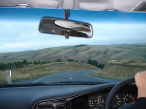
Aaaaand so we were off! and after four hours of driving through the dry, rugged terrain of Central Otago, found our way to a motorpark camping area on the shore of lake Hawea, which looked lovely in the moonlight.
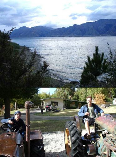 The five of us, Matt, Thimo, Ted, Shannon, and I, squeezed ourselves into two two-person tents and drifted off to snoozy land. Yes, we became a little closer that night, Matt, myself and Thimo spooned (in that order) intimately in the small tent. The next morning we were startled by Hawea’s beauty, especially the mountains across the lake that were barely visible by moonlight. We had ourselves a belly-filling breakfast of baked beans on toast, fruit and cheese, which may or may not have inspired Matt and I to give the immobile tractors on the playground a sporting ride (note the fancy flask filled with Jack in his right hand, essential for a tractor-riding boy from Tennessee).
Seeding the Adventure
We left Hawea with a taste of the scenery on our lips, looking forward to the delicate flavours of Mt Aspiring and Rob Roy Glacier, where we had decided to hike and camp for the remainder of Saturday and Sunday.
 The Department of Conservation provided us with some pertinent information, including, “Yeah, you have to ford the river a few times to get to the carpark, but as long as you have insurance, or don’t care, you shouldn’t have any problems.” This is where our thoughts of adventure began – I had never driven a car through a stream or river, and I don’t think the other had either…The drive through the countryside around the western shore of Lake Wanaka was gorgeous. I had to be careful not to let my camera trigger finger get to happy, because I knew there would be plenty of pictures to take on our hike.
 Fording!
New Zealand has all-purpose (!) signs to which they attach a specific hazard of some sort, and this time the hazard was FORD: a point where a stream or river must be crossed. We were expecting these fords, but we were not expecting five of them! We decided that to properly commemorate these crossings, we would take a picture at each one, however, for your enjoyment, I have included only the picture of the best of the five, where the happy car-full of four forders excitedly entered the stream with a SPLASH! You can see, in the background, the waterfall that feeds the stream – a feature that wowed us at that point, but would become a common feature of the mountain-sides as the trip progressed.
Tititea / Mt Aspiring National Park
Mt Aspiring National Park is in the centre of Te Wahipounamu (the place of greenstone), or South West New Zealand, a UNESCO World Heritage Area, that incorporates Aoraki/Mt Cook, Westland/Tai Poutini, Fiordland, and Mt Aspiring National Parks, covering 2.6 million hectares or 10% of New Zealand’s land area. Wow. In this area of snow-capped mountains, rivers of ice, deep lakes, unbroken temperate rainforests, and tussock grasslands live some of the best examples of animals and plants once found on the supercontinent Gondwana. Again, for those geologists out there, to quote the information sign at the carpark: “The rocks of the Southern Alps began as layers of sediment and rock deposited on the seafloor about 220 to 270 million years ago. They were subjected to intense heat and pressure before being uplifted to form mountains. The force of the glaciers, which filled most of the surrounding river valleys at the height of the Ice Ages, shaped the current landscape. Today, Mt Aspiring National Park retains about 100 glaciers.” The West Matukituki Valley, where we entered, is the eastern gateway to Mt Aspiring National Park, the third largest national park in NZ.
The Hike Begins
From the carpark we were told that the hike to Mt Aspiring hut, the first official bunking and camping site along the Mt Aspiring Trail, was about a 2.5 hr hike, so we decided to take it on.
 Just as Matt, the first of us to step onto the official trail, set his left foot down in the gravely dirt, the temperature dropped 7 degrees, 50mph winds gusted forth, the clouds cracked open, and angry rain began sharply spitting into our faces – this is how it seemed, as if the gods of Mt Aspiring were watching as we got out of the car (when the weather had been calm, sunny, and altogether pleasant) and were attempting to thwart our efforts to move forth. But we did not let them scare us away! No! We put on our waterproof jackets and trotted out. Much of the more grandiose scenery was shrouded in cloud-cover, but the view nonetheless was spectacular. The trail followed the West Matukituki River between two ranges of mountains, with mostly cows and sheep spotting the grassy flats of the valley. The intense rainfall contributed to a couple of precarious and unavoidably damp river crossings, but these were the only major obstacles to come between us and the Mt Aspiring Hut, where we arrived late in the afternoon, set up our tents, dried off and warmed up, had a bite to eat, explored a little, and finally retreated to our warm sleeping bags.
Feathered Invaders, Scavengers
We woke up at 6:30am to a refreshingly clear morning, a spectacular sunrise above the valley and the now-visible mountains, and a dozen forest parrots gnawing on our tents.
 You could question who the real invaders were, us or the parrots, but regardless, they were eating whatever gear they could get in their sharp, strong beaks. May I introduce: the Kea. Kea are a species of forest parrot that live in the temperate (especially beech) rainforests of New Zealand. I am unsure of the composition of their diet before humans came along, because they have a sweet-beak for tents, backpacks, shoes, clothing, and just about anything un-natural to their locality – they have even been known to prey on the non-metallic parts of automobiles! We could not help falling for these cheeky birds, even though, as one kiwi girl camping outside said, “Don’t you know that they can rip you apart with their beaks? I’m not kidding!”
Her Majesty
We packed up camp and got dressed for a little romp through the woods, our destination a flat that opens up to give a magnificent view of Tititea’s / Mount Aspiring’s peak.
 In the picture included, Mt Aspiring is on the top right. Believe it or not, Tititea, which translates as Glistening Peak in Maori, at 3,033 meters (9,944 ft), is the only peak above 3,000 meters outside the Aoraki / Mount Cook region. We stood in awe for at least ten minutes. We then turned around and headed back from whence we came on Saturday, back to the bridge over the West Matukituki River where we could hop on the trail to Rob Roy Glacier! Click here for a panorama of the area we walked through.
Fern Forest and Glacial Grandiosity (yay!)
 After crossing the river and hiding our packs in the woods, we embarked on our 1.5 hour uphill journey through the fern-filled temperate rainforest. We stopped at one choice point to fill our Nalgenes with glacial stream water – why not! It was, of course, delicious and refreshing, refreshing enough to temp us toward a little swim later in the day…
 The trail carved into the hillside followed the stream up the mountain to its source, the Rob Roy Glacier. The glacier, known to many as the “Jewel of Mt Aspiring National Park,” begins (at 2,606 metres) high above Rob Roy Peak, clinging to the ever-steepening mountainside as it descends into the Rob Roy Valley. We were not lucky enough to see any huge chunks fall off, but it was a lovely place to stop and eat lunch, and, of course, a great photo ‘op.’ Another highlight of the area are the waterfalls, the largest of which (pictured earlier) falls 150 meters from peak to valley.
 We decided it would be a GREAT idea to catch a swim in the glacial stream on our way back, since we had by this time worked up quite the sweat, yeah (**wiping off forehead and flexing legs**). The dip in the stream was great, mostly because it meant that I didn’t need to shower again for a few days (one thing that hasn’t changed during my stay in NZ is my infrequent tendency to shower 2-3 times a week…). Many people glanced and/or stopped to watch us while we romped around in the water, sort of like creatures at the zoo, but awkwardly outside of their natural habitat. They may have just been jealous. Heck, I would be! No one joined us, however, they were either too young, too old, or too middle-aged to do those sorts of things. Ah well. We drank the rest of our glacial water on the hike back to the car, met up again with Shannon (who had decided to sit out for Rob Roy), and headed back to Dunedin!
 [Sounding & Resounding]
This trip took me to the most beautiful places I have ever been in my life (so far). The fact that New Zealand holds so many diverse formations, biomes, ecosystems, and therefore plants and animals, on their two small islands continues to astound me. I’m loving it, and can’t wait for more adventures in the future.
Cheers!
Danno
posted by Dan @ 3:47 PM
0 comments
![]()


0 Comments:
Post a Comment
<< Home